NC Standards
EEn.2.1 Explain how processes and forces affect the lithosphere.
EEn.2.1.1 Explain how the rock cycle, plate tectonics, volcanoes, and earthquakes impact the lithosphere.
EEn.2.1.2 Predict the locations of volcanoes, earthquakes, and faults based on information contained in a variety of maps.
EEn.2.1.3 Explain how natural actions such as weathering, erosion (wind, water and gravity), and soil formation affect Earth’s surface.
EEn.2.1.4 Explain the probability of and preparation for geohazards such as landslides, avalanches, earthquakes and volcanoes in a particular area based on available data Unpacking What does this standard mean a child will know, understand and be able to do?
EEn.2.1.1 • Explain the rock cycle in enough detail to relate the cycling of materials - formation and destruction of the three major rock types to the forces responsible: physical and chemical weathering, heat and pressure, deposition, foliation and bedding. The forms of energy that drive the rock cycle include heat and mechanical (gravitational potential) energy. • Explain how various mechanisms (mantle convection, ridge push, gravity pull) drive movement of the lithospheric plates. • Infer the relationship between the type of plate boundary and the locations of various features such as ocean trenches, mountain ranges and mid-ocean ridges. (Relate to the development of the theory of plate tectonics and geologic time.) • Compare magma and lava. Locate volcanoes and relate back to plate boundaries. Explain volcanic effects on the lithosphere and relate back to plate boundaries (convergent, divergent, transform) including lahar (mud) flows and ash in the atmosphere. • Describe the anatomy of an earthquake. Locate earthquakes – epicenter and focal point – and relate to different types of plate boundaries. Explain how the release of energy of various types of earthquakes relates to magnitude, and P and S waves. • Summarize the major events in the geologic history of North Carolina and the southeastern United States. Explain how current geologic landforms developed such as Appalachian Mountains, fall zone, shorelines, barrier islands, valleys, river basins, etc. using the geologic time scale. • Explain how processes change sea-level over time—long- and short-term. Infer the effects on landforms such as shorelines and barrier islands.
EEn.2.1.2 • Infer the locations of volcanoes, earthquakes and faults (strike-slip, reverse and normal) from soil, geologic and topographic map studies. (Relate fault locations/types to plate boundaries.) • Make predictions based on data gathered over time in conjunction with various maps.
EEn.2.1.3 • Recall that soil is the result of weathering of rocks and includes weathered particles: sand, silt and clay. • Explain differences in chemical and physical weathering and how weathering rates are affected by a variety of factors including climate, topography and rock composition. • Compare erosion by water, wind, ice, and gravity and the effect on various landforms.
En.2.1.4 • Conclude the best location for various types of development to reduce impacts by geohazards and protect property. • Explain precautions that can be made to protect life from various geohazards and include meteorological hazards. Some examples include landslides, earthquakes, tsunamis, sinkholes, groundwater pollution, and flooding.
EEn.2.2 Understand how human influences impact the lithosphere.
EEn.2.2.1 Explain the consequences of human activities on the lithosphere (such as mining, deforestation, agriculture, overgrazing, urbanization, and land use) past and present.
EEn.2.2.2 Compare the various methods humans use to acquire traditional energy sources (such as peat, coal, oil, natural gas, nuclear fission, and wood).
EEn.2.2.1 • Explain the need for and consequences of various types of land use such as urbanization, deforestation and agriculture. • Explain ways to mitigate detrimental human impacts on the lithosphere and maximize sustainable use of natural resources. • Explain the effects of human activity on shorelines, especially in development and artificial stabilization efforts. • Explain the effects of human activity on mountainsides, especially in development and artificial stabilization efforts.
EEn.2.2.2 Compare the methods of obtaining energy resources: harvesting (peat and wood), mining (coal and uranium/plutonium), drilling (oil and natural gas) and the effect of these activities on the environment and explore alternative energy technologies to get a more complete picture of possible sources of energy for human use.
Vocabulary
lithosphere
rock cycle
sedimentary rock
metamorphic rock
igneous rock
magma
lava
erosion
weathering
deposition
tombolo
spit
barrier islands
sea arch
sea stack
core
mantle
asthenosphere
plate tectonics
crustal plate
oceanic plate
continental drift
fault
stress
earthquake
volcano
epicenter
focus
geohazard
rock cycle
sedimentary rock
metamorphic rock
igneous rock
magma
lava
erosion
weathering
deposition
tombolo
spit
barrier islands
sea arch
sea stack
core
mantle
asthenosphere
plate tectonics
crustal plate
oceanic plate
continental drift
fault
stress
earthquake
volcano
epicenter
focus
geohazard
Lithosphere Quizlet
Geological Timeline
| geological_time_webquest.doc |
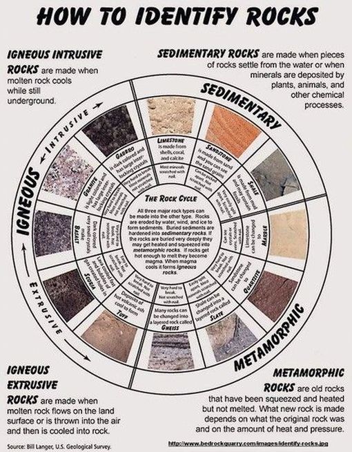
Rock Cycle
Learning Targets
I can explain the rock cycle, including the formation and destruction of the three major rock types and the forces responsible.
Introduction to Rocks
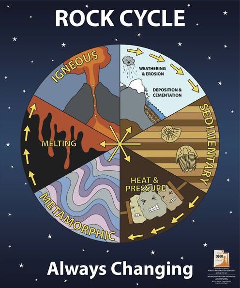
https://en.wikipedia.org/wiki/Rock_cycle
Rock Cycle Investigation
http://www.classzone.com/books/earth_science/terc/content/investigations/es0602/es0602page01.cfm?chapter_no=investigation
Virtual Minerals Lab
Virtual Rock Lab
Rocks and Minerals Webquest
| rocks_and_minerals_webquest_1_.docx |
Weathering, Erosion, and Soil Types
Learning Targets
I can explain the differences between chemical and physical weathering and how weathering rates are affected by a variety of factors including climate, topography, and rock composition.
I can compare erosion by water, wind, ice, and gravity and the effect on various landforms.
I can recall that soil is the result of weathering of rocks and includes weathered particles; sand, silt, and clay.
I can compare erosion by water, wind, ice, and gravity and the effect on various landforms.
I can recall that soil is the result of weathering of rocks and includes weathered particles; sand, silt, and clay.
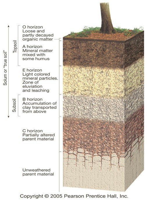
https://doityourselfforestryblog.wordpress.com/2016/05/27/what-are-the-different-soil-horizons/
| 05.weathering_soil_and_mass_movements.ppt |
Breaking it Down
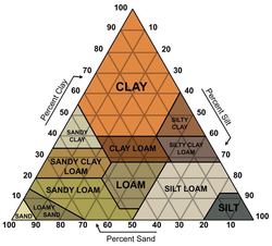
Plate Tectonics
Learning Targets
I can describe and illustrate the anatomy of an earthquake.
I can describe the sources of power that move Earth's tectonic plates.
I can compare and contrast the different types of plate boundaries.
I can describe the features found at different plate boundaries.
I can explain how plate boundary features provide evidence for the Theory of Plate Tectonics.
I can describe the sources of power that move Earth's tectonic plates.
I can compare and contrast the different types of plate boundaries.
I can describe the features found at different plate boundaries.
I can explain how plate boundary features provide evidence for the Theory of Plate Tectonics.
| 08.earthquakes_and_earths_interior.ppt |
| plate_tectonics_webquest.pptx |
What is a fault and what are the different types?
Volcanoes
Learning Targets
I can identify the different types of volcanoes.
I can explain how volcanoes impact Earth's environment.
I can explain how volcanoes impact Earth's environment.
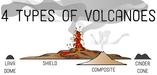
https://owlcation.com/stem/4-Different-Types-of-Volcanoes-Cinder-Cones-Lava-Domes-Shield-and-Composite-Volcanoes
| 10.volcanoes_and_other_igneous_activity.ppt |
Volcanoes and Current Activity Alerts
The Yellowstone Caldera Chronicles
What was recorded earlier this week at Yellowstone?
Knowing what you now know about volcanoes, what do you think would happen to the US if the caldera were to erupt?
Would NC be effected? You may use other internet sources to back your reasoning of why or why not. You must cite these sources
Knowing what you now know about volcanoes, what do you think would happen to the US if the caldera were to erupt?
Would NC be effected? You may use other internet sources to back your reasoning of why or why not. You must cite these sources
Virtual Volcano
Hawaiian Islands
Human Impact on the Lithosphere
Learning Targets
I can explain the consequences of human activity on the lithosphere.
| human_impact_on_lithosphere.pptx |
| human_impact_on_the_lithosphere_powerpoint.pptx |
Terrace Farming |
Filter Strips/ Buffers |
Surfrider Foundation: Shoreline Structures
Renewable Energy : UNCW Curriculum
| ppt-renewable-act__1_.ppt |
